| From The
Sea CanoeistVol.3, 1980.
South Coast and
Maatsuyker Island.
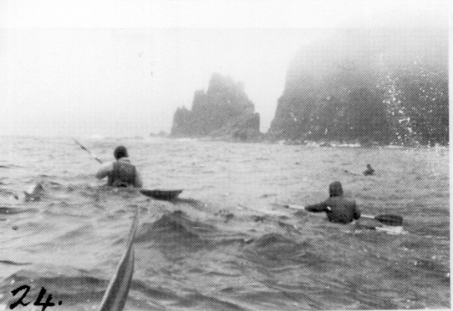
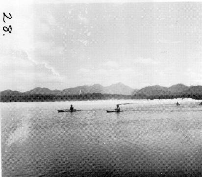
Led by Tony Gaiswinkler, Mike Emery, Les Linsell, Paul Davis, Cecily Butorac. Arrived at Cockle Creek about 10.30am Thursday and packed the canoes on the beach while talking with the Mercury reporters and photographers and family members who came down to see us off. Found I had an attack of the butterflies, not really about the trip itself but apprehension about having to land in really big surf, especially after what happened to the men on last years West Coast trip. I found packing my canoe via my new hatches quite different to previous trips, but even so I managed to be first packed - probably the only time for the whole trip. We set out across Recherche Bay with a stiff breeze against us from the east, but very soon had to stop to tape a fracture in Mike’s canoe - the result of a bumpy ride in to Cockle Creek on the car. Once out and around the point the sea was choppy but quite OK and we all paddled eagerly, feeling the excitement of the start of something big. There was a bit of ground swell in places along the coast until we rounded Whale Head which meant we had to keep our minds on the job and not gape too long at the scenery. Just as we came around Whale Head there was this wonderful feeling of being lifted from behind and carried by the swell, instead of trying to fight it as before. That was when I really started to enjoy the trip. It was another good moment when we all gathered just on the east side of South East Cape and then away we went one after the other round to the real South of Tasmania. There were some impressive swells crashing against the cliffs and a bit of turbulence from the swells being reflected back off the cliffs to meet the oncoming swells - known in canoeing circles as ‘haystacks’. We reached South Cape Rivulet and found only a mild surf running in the corner near the campsite, so we easily reached the rivulet and paddled upstream to the delightful campsite set under tall straight eucalypt trees behind the rivulet and beach. Some walkers were already camped and more came plodding in a bit later, weighed down by their heavy packs. I was thankful that canoeists have to lift only a lightweight paddle, they take their exercise sitting down, and it is all on a horizontal plane. It began to drizzle so we rigged up a tent fly near the fire and Mike carried his canoe up near the fire to thoroughly dry it before doing a proper repair job on the fracture we’d had to tape up at the start of the trip. Next day still drizzle, but repairs were done to Mike’s boat, Les’s rudder and Tony’s rudder. In the afternoon we all walked back eastward to Lion Rock where the South Coast track leaves the coast to go across to Cockle Creek. Lion Rock is sheer rugged rock on the west side but browny vegetation on the east - just the right shade for a lion. There is a dark sea cave facing appropriately out to sea, whilst his head obviously growls at the shore. There is a silver gull rookery on the east side and we watched the birds hanging like kites on a string as they rode the up-draughts of air above the rookery. It was now sunny and very pleasant as we returned to the same camp for another night. Off again in the morning but the same drizzle had returned and one had the impression of the world having been turned into a colourless place in shades of grey. The drizzle filled the air and shrouded the rocky coastline, blotting out most details and all colour and the sea was a leaden grey. Probably the south coast is wrapped in such wet grey drizzle for much of the time, so we felt it must be accepted as one of the moods of the area. We passed Soldier Bluff and just ahead was the great South Cape, a massive fist thrust out in defiance at the Southern Ocean. Although the sea was very moderate the rugged shore broke the swell into impressive displays of spray and foam. An added interest on this misty grey day was occasional visits by various sea birds. My favourites are the Gannets, large white birds with black markings and a yellow patch on their head. They always come right overhead for a good look and you can almost imagine them giving you a cheery greeting. The Albatross is a marvel to watch with its enormous wingspan, as it soars effortlessly on the currents of air over the water. The Albatross is much more interested in fish than in canoeists. Then there are the exquisitely shaped Terns with such sharp clear line and a brisk movement in the air. I always wish I had a more thorough knowledge of sea birds, especially when you see the staggering number of Mutton birds at sea for the day. They seem to flow along in rivers of birds following after each other to their feeding grounds. I have watched them ‘rafting’ in a huge black cloud on the sea as they fed.
After South Cape the Fluted Cliffs loomed darkly out of the mist, their tops wreathed in white shrouds. We were taking a ‘lolly stop’ about here when a light aircraft flew past, obviously intending to go to the Port Davey area, but it soon returned having found the visibility quite impossible further west. It flew over us and waggled its wings as we waved a paddle. I guess we must have looked tiny down there below those massive cliffs. Shoemakers Point followed by Prettys Point soon passed on our right and we could see Hen Island with its smaller Chicken Island ahead, which meant Rocky Boat Inlet was behind the next point.
As we rounded Point Vivian we saw swells building up on the reefs at the entrance to the inlet, making a formidable barrier. However the real advantage of canoes showed up as we found a route on the western side which slipped in behind some rocks into a sheltered area which had a sandy bottom and clear green water perfectly calm. From here we had easy access to a sandy patch on the shore to land. Because the area looked good for diving, we decided to make camp here, although it was only the middle of the day. The campsite was in a patch of Tea-tree scrub near a little creek, which ran with the usual brown stained water typical of button-grass country. The day was definitely not warm and so only Tony and Paul were tempted to dive, as they had adequate wetsuits. They soon produced enough abalone and crayfish for a superb evening meal. Mike and Les and I walked over to New River mouth in the afternoon through wet scrubby areas with plenty of mud. My nice dry boots were soon squelching with mud, and I made the mistake of rolling up my slacks to keep them dry which gave a glorious opportunity to every leech in creation to latch onto me. Several had a got a really good grip before I found them and so for the next week I had to resist the urge to scratch their bites which were a great torment. I found a bandaid spread with a bite cream the only help. The mouth of New River enters the sea at the eastern end of Prion Beach, a great sweep of broad white sand with lines of breakers as far as we could see into the mist. Next day we left Rocky Boat Inlet and crossed Prion bay, calling at Deadmans Cove for lunch. This is an excellent sheltered little cove again ideal for canoeists only, as it is protected from the swells by a heavy growth of kelp with rocks here and there. The rain forest reaches down to hang over the round boulder shore - so unlike the areas up the east coast of Tasmania with beaches and sand dunes and low scrub all along. The ferns and moss-covered trunks seem somehow unrelated to the salty environment they overlook. We were invited by a party of 6 walkers to share their campfire for lunch and found one in much difficulty with a strained knee. He had crossed the Ironbound Range the previous day and found the combination of wet conditions and large numbers of walkers had reduced the track to an unbelievably bad state. We tried to use our two way radio to seek help but found it impossible to make contact that day. We later heard he had been picked up by a fishing boat. From Deadmans Cove we paddled along to Louisa Bay to camp. The entrance to the bay is dominated by Louisa Island and a couple of smaller islands. I was surprised to see how big Louisa Island is, having seen only an aerial photo of that corner of the bay. Louisa River is another dark brown stream draining button grass and Tea-tree areas. Although it is very shallow as it emerges into the sea, further up stream it is wide and deep. We camped in a good sheltered spot among the dunes under Tea-tree and Acacia trees with the usual little brown stream trickling past. Actually this one was more the outflow of a soak but tasted about the same as the others. It surprised me how one just accepts such water when it is all there is. Tony and Paul dived and presented us with abalone and common warriners for tea.
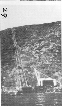
Next day we explored the dunes looking at aboriginal middens, their shells and stones emerging from the weathering parts of sand dunes. Obviously the aborigines in this area lived well on sea food, but we realised in that climate they would have needed a lot of food to survive. We paddled our empty canoes up-stream on Louisa River and disturbed some ducks and swans. One swan seemed too young to fly and would have been an easy target to catch had one not been a law-abiding citizen. Louisa River winds along banked on either side by mostly Tea-tree scrub, with occasional grassy banks kept cropped short by wallabies no doubt. The day was still and warm with clear sky and we felt no urgency to hurry, although it meant we enjoyed only the immediate area of Louisa River and Island, whereas there is a great deal more in Louisa Bay to explore. On returning to camp I was utterly dismayed to find the warmth had attracted the blowflies to one of my plastic bags of woollen clothing. There was one pair of sox which were a little damp and might be said to be a little aromatic at that stage, and so the flies had attacked in force. I furiously shook out everything, but found a thorough wash was the only solution for several items. After that I always left my bags tied up. We decided to shift camp that afternoon to De Witt Island. We left Louisa River in hot sunshine but with a stiff breeze, so it was jumpers and jackets all round and a good idea too as the sea was choppy and often broke over us and the fresh breeze was pretty cool. Just as we left Louisa Island there were some big swells crashing over the reef, and I wondered how rough the crossing to De Witt would be. However it was well within our ability, even if good and lively. The lone rock jutting up about halfway over was breaking some spectacular swells. The landing place at De Witt was a jagged rocky inlet with a good surge making it necessary to take it one at a time and help the next paddler. Once we were all ashore we looked about for a suitable campsite - there seemed to be a sea of six foot high bracken all around, with a small brown creek trickling through it. Tony and Paul soon discovered that the bracken concealed a bird rookery, and parts of this were more open. I was feeling dismayed at the thought of camping with mutton birds in among bracken, with a possibility of the company of the usual snakes that occur in bird rookeries. However a first class campsite was soon found in behind the tree line and what a delight it was. The creek provided water, which actually looked more like tea before you added the leaves - after you added milk it closely resembled the water you just washed your muddy sox in. It tasted good though - different, but good. The campsite ground was soft underfoot with its great depth of leaf mould and moss. Ferns grew everywhere, and tall myrtle and sassafras shaded native laurel and flowering leatherwood. The birds in this little rain forest sound loudly and so musically compared to the harsh raucous calls of mountain jay and cockatoos at Louisa River. It was an endless pleasure to just sit still and listen to the sounds of the bush. Our tents fitted in among the ferns and trees very snugly, except Mike’s was covering a bird burrow. After a good meal cooked over a beautiful campfire, the evenings entertainment began. A while after dusk, about 9.30, a whirr of wings overhead heralded the return of the mutton birds and soon there was a rustling in the bracken which proved to be the penguins pattering up their little roads to their burrows. I was so surprised to hear the cacophony of sound which they all produced. The mutton birds squawked loudly and long and the penguins cries were a deeper more powerful shriek, sometimes resembling the hee-haw of a donkey. The sounds intensified to a crescendo around 9.45 and carried on for about an hour. As it turned out, our tents were on a penguin road and they resented us a lot. A few mutton birds just flew into their burrows near us, but the poor penguins were lining up just below the camp in a state of bewilderment. Eventually several plucked up courage and toddled right by us with a determined step. After we’d settled in our tents a couple tried to reach the burrow which was covered by Mike’s tent fly. Both Mike and the penguins were startled to find themselves eyeball to eyeball in the dark. Eventually peace reigned until the birds began their usual early start to the day - around 4 am. The whole squawking shrieking bedlam was turned on again for a while but was soon replaced by the melodious song of the bush birds in the early dawn. We didn’t make an early start because of a strong wind warning and decided to spend the day exploring the island on foot. The five of us set off uphill from the camp and enjoyed the wonderful greenness of the rain forest. Along with the soft wet moss covering ground, fallen logs, stumps and trunks, many smaller shrubs were decked in lacy tufts of green lichen which was yellow on the underside. Each lichen was basically alike, and yet there were no two the same. Some of the flowering leatherwood trees had low branches and we could smell the familiar leatherwood honey as we passed. Another aroma we noticed was the smell of wet rain forest. The island rises from a low basin on the north side to a high rim about 300m on the south side, which falls sheer down to the sea. As we climbed higher it became steeper and although the air in the forest was still we began to hear the wind whistling in the tall timber above us. Eventually we stood on the very rim looking down on an almost vertical scrub covered cliff, up which the wind blasted with surprising force. The sea was a white capped wilderness which looked very inhospitable to any craft, especially our canoes. We worked our way along the rim amongst thick forest growth which to me was surprisingly tall and straight considering the winds which must blast the top of the island. The others pointed out that the winds were shooting straight up the cliff and thus the top area was quite protected. The highest point on the island is towards the SW corner and from the top of a banksia tree among thick scrub we took photos of Maatsuyker Island and Walker Island and Flat Witch Island set in their surrounds of white. On returning to camp we made tea and a challenge was issued to find the best pancake maker. Tony and myself were the contenders and Paul declared himself the judge, claiming an adequate supply of pancake samples on which to make a fair judgement. After some constructive criticism of the quality of our efforts, no doubt to ensure that we would try again another night to do better he declared the contest a tie, probably for the same reason. We decided the next contest was to be a damper making challenge between Paul and Mike. The early forecast next day was for moderating seas and wind so we decided to spend another day on the island before trying for Maatsuyker, thus allowing time for the ‘heavy short swells’ to subside. I rather imagined another walk in the rain forest would be much like the first one, but it was a whole new experience. The east side of the bowl shape was even lovelier then the southern side. There are no tracks anywhere on the island, so the idea is to take a good look at the map, decide where you’re going, then go. It meant a tortuous scramble through scrub, over and under logs, jumping creeks, and falling down burrows, but always a sense of wonder at the incredible beauty all around. We burst out of a steep patch of thick bushes and there was a steep sweep of ferns entirely carpeting the ground shaded by massive tall myrtles, dogwoods in flower and native laurels glistening green with a touch of pink. Another damp hollow was filled with huge man ferns spreading wide their fronds. No fire had touched these for sure, and several had sturdy trees growing out from their trunks. We reached the high granite outcrop on the NE corner, Baldey Point, and climbed up for a spectacular view right along the south coast of Tasmania. The backdrop of mountains from Pinders Peak in the east to the far western ranges was a sight never to be forgotten. We could trace our route from S Cape westwards past Ile Du Golfe to Louisa River quite easily. The coast from Louisa Bay west to SW Cape looked attractive but we realised it would have to wait till another time. The sea was calm that afternoon, and we probably should have made a run for Maatsuyker Island then, however we decided to move first thing in the morning. The incredible intensity of the mutton birds not only woke me around 4am but stirred me enough to get up and investigate. It was still dark but I could see enough to walk down to the creek and listen in amazement to the intense whirring humming sound which seemed to be always building up without ever reaching a peak. You could almost feel the vibrations and it communicated a kind of excitement of anticipation. The penguins guttural sounds were all around, and before long they started to emerge from their burrows and the great exodus began. We packed our boats once more and left De Witt Island with a distinct twinge of regret along with a great excitement at heading for Maatsuyker. The sea was beautifully calm for paddling, some nice swells breaking over the rocky shore but nothing to bother us. We reached Flat Witch Island and paddled round the west side for a look at an incredibly jagged rocky shore capped by thick green vegetation. The landing at Maatsuyker was in a gulch on the east side, and we could see the cable way standing out clearly from a distance.
The gulch was a very sheltered spot from almost all winds, and Tony and Paul paddled in ahead of us looking carefully along the rocks for something. Not until afterwards did Tony reveal that he had been told by the lighthouse keeper to be very wary of the seals at Maatsuyker as they were giving birth to their pups and were very aggressive at this time, and that packs of sharks tended to hang around to scavenge whatever they could, as well. We did see a pair of seals in the gulch but they had no pups, and the main seal colony is based on rocks off the south end of the island, so we were well away from them. We pulled our canoes up on to the rocks - a much easier landing site than at Tasman Island. Taking a lunch bag each we set off up the cableway on foot. Tony had phoned from the landing stage, but the keeper’s wife explained that the two men were at the heliport to meet the helicopter. The cableway rises one in one near the bottom, and was a strenuous climb. We wandered along the jeep track from the top of the cableway and eventually met the jeep, after having watched the helicopter make its brief visit. All along the jeep track tea-tree grow thickly, sometimes meeting overhead. The trunks are twisted and contorted as though they had emerged from a Van Gough painting. We saw a sign indicating ‘Olympic Pool’, so we scrambled up a muddy hillside and found an ancient reservoir of small proportions thickly grown with water weed. Once we met up with keeper Gill and his assistant, Peter, in the jeep we were loaded into the back of it and had a very bumpy ride first back to the heliport to turn the vehicle around then all the way along to the lighthouse. We were given numerous lengthy warnings about restrictions on our activities which no doubt are routine to all visitors. The lighthouse stands 110m above the sea on the south corner and commands a superb view over the Needles rocks, where the seal colony is established. We watched the seals through a pair of binoculars, but it needed a much stronger magnification to really have a good look. We were shown over the lighthouse, and Gill explained the works of the system and the various back-up facilities in the event of light failure, right down to the ultimate of a hurricane lamp hung in place of the lightglobe and the whole mechanism revolved by a hand crank. This method was only used once - and that was for a film to be made. We saw the charts indicating cloud formation and wind speeds and sea conditions, and to our dismay saw that the barometer was taking a rapid fall. In fact whilst we were at the top of the tower the first squall came and whipped up the sea.
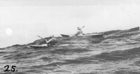
We decided not to attempt to stay overnight due to the restrictions imposed on camp fires, lack of water and so on. Without getting an opportunity to walk down to the point nearest the seal colony, we were loaded back into the jeep and taken back to the cable way. The ride down on the tiny cable car was breathcatching indeed, but I did manage to take one photo looking sideways to show the incline. Not having had the opportunity to eat lunch, we sat on the landing stage for a few minutes and hastily consumed a quick snack, but of course we missed out on a drink. The sea had calmed since that first squall, but knowing the barometer was falling rapidly we set out for the eastern side of De Witt Island and from there to Ile Du Golfe and Rocky Boat Inlet. It was great to paddle round under the cliffs which we had previously climbed on foot. They looked every bit as spectacular from a tiny canoe at the bottom looking up as they had on that windy day when we stood on the top. From De Witt Island it was a long stretch of open water to reach Ile Du Golfe, and with a rising NW wind Paul and I found we were having to use more and more correction strokes as our canoes had no rudders. Somewhere out there a fishing boat loomed up and came over for a chat. They seemed a bit surprised to see us way out there in a rising sea, and offered us a lift back to Dover. We declined the lift but I suggested we could use a good cup of tea - an idea that was greeted with great gales of laughter. Little did they know I would have simply loved a good cup of tea. They decided we surely must ‘have rocks in head’ to be indulging in such a crazy game and went on their way to Dover. By the time we reached Ile Du Golfe the wind was gusting pretty strongly and just as we came round the southern point a really wild gust swept along filling the air with driving white spray and causing us to brace hard with our paddles to maintain stability. We found that this was the pattern on what we had expected to be the sheltered side of the island. The gusts struck from any direction, lasting only about 30 seconds, but of surprising force. We rafted together for a short rest in a small inlet beneath the dramatically steep side of the island, and although I felt unusually tired, the idea of getting to the end of the day’s paddle lured me on. Tony suggested Les and I go round the east side of Hen Island to get to Rocky Boat Inlet. However with the wind now blowing hard from the NW my canoe kept turning towards north and it seemed like a straight line to our destination if we stayed on the west side of Hen Island. What a blunder. The big swells bounced back off the cliffs and gave us a mighty lively time struggling through ‘haystacks’ and paddling very strenuously to avoid being blown onto the rocks. It was quite a frightening experience. A fishing boat came through the passage in front of us and I watched the spray from its bow blow right through its rigging and well out behind the boat before dispersing. It surprised me how ones tired muscles can still draw power in such an event, when one’s adrenalin is freely flowing. Our second blunder followed straight on the first, when we failed to recognise Rocky Boat Inlet, and thought we had one more point to go round. We began to run with the swells towards the second point when I suddenly realised the error, and called to Les who was 50m ahead. We then had to turn our canoes and battle our way back and finally reached the shore dead tired. As Tony pointed out, our maps should have been on our decks for instant reference, to avoid such errors. It wasn’t until we’d pitched camp in among the tea tree that the real fatigue hit me. I changed into dry clothes and intended to help cook tea but kept getting an irresistible urge to lie down and sleep. In the end sleep won, and only the kindness of the others provided me with hot food and drink between dozes. Next day the gale still blew, interspersed with showers. I spent nearly all day in my tent, mostly asleep, occasionally trying to read. By late afternoon even I had slept enough, and walked around the shore marvelling at the fury of the sea. Spray was airborne right along the shore, and out at Hen Island and Ile Du Golfe you could see waterspouts being swirled up off the sea to reach as high as the top of each island. Not a good place to be paddling a canoe. The others had decided to move the campfire to a very sheltered spot some 50m away up past a little creek, so with a tent fly stretched between some handy trees we had a much better place to cook and eat that night. The wind did not die all night, and even seemed to lash with renewed fury at times, so by Saturday morning the others decided to shift their tents up by the new campfire. Mine was very wind resistant and in a good spot, so I left it there. Spent the day by the fire or reading and writing notes on the trip. Sunday certainly was a lot calmer and it steadily improved all day. The forecast was favourable for making the return trip to Recherche in one day with a following wind, so we planned an early start on Monday. On Sunday morning Tony and Paul had been diving and produced the usual haul of crays and abalone. I tossed in a handline and a suicidal kelpie grabbed it straight off. We feasted on seafood for lunch and some of us had more for tea. In the afternoon we walked eastwards to Osmiridium Beach and watched the lines of breakers making a great show of white water all across the bay, although the actual swells were not really very big. After tea we packed what we could in our boats ready for an early start. The roar of the wind in the trees woke me around first light and the splatter of rain on my tent soon followed and my spirits sank. However I began to pack the overnight things and a bit later we gathered at the edge of the scrub to review the situation which we decided looked bleak. However after hearing the forecast we decided after considerable discussion to move out, see how it felt and try to make South Cape. From here we could either continue to SE Cape or make for South Cape Rivulet. It was certainly rough and demanding and we kept fairly closely in a group. It gives a lot of moral support to have other paddlers nearby in bad conditions, even though we all realised that to perform a deep water rescue in such heavy seas would be extremely difficult. A few times the sky cleared a little and I felt maybe the worst was over, then another squall would come tearing in. The haystacks made for difficult paddling as there is no regularity in the swells, and one will unexpectedly break just when you’re on its crest. By the time we approached South Cape I felt a strong desire to get out of these seas with all speed, and I think the others all agreed. In fact I privately felt that no matter how big the surf at South Cape Rivulet was it couldn't be worse than struggling along in these conditions. Tony decided we’d head for the rivulet and have a look anyhow. This meant we were in rather calmer waters with more of a following sea and fewer haystacks and we anxiously watched ahead for signs of the surf. It looked worse from a distance actually, and the nearer we came the better we could see that right at the outlet of the rivulet it should be possible to charge through safely. We all managed to come through upright, riding the waves after they broke, in a side on position braced with our paddles well over into the wave. Solid sand never felt so good. We made a little fire on shore and put up the radio aerial for a sched to hear the forecast and give our position. Decided to stay the night so paddled upstream to the campsite and relaxed gratefully round the fire over tea. Tuesday saw us away early on a much calmer sea and we covered the 24km back to Cockle creek without any difficulty. It had been a magnificent experience, often demanding, sometimes frightening, but always exhilarating. Cecily Butorac.
|